General geology of the Ural
If I had to describe the geology of the Ural in a single sentence it would be ' the metamorphic faultzone formed by the collision of the Siberian craton and the East European craton'. But this would not do justice to the complex geology of the Ural.
The geology of the Ural starts in early as the Precambrium. Back then the area was an ocean. To the west of the ocean lays Europe. The precambrean rocks of this old continent (craton) can still be found in for instance Scandinavia, Kola and Timan. To the east lays the Siberian continent or craton. In the Riphaen (younger precambrium) both continents moved away from each other. The result was a rift zone, much like we see today in the center of the Atlantic ocean. Basic and ultra basic rocks are formed along the rift. This process continued for many million years until the Silurian. Today we still see many traces of this rift activity in the form of numerous ultrabasic rocks in the Urals. Examples are the Dunite-Harzburgite rocks or the rodingites of Bazhenoskoye. The many platinum and chromium occurences find their basis in these ultrabasic rocks
In the Silurian a subduction zone developed at the west side of the Siberian craton. This means that the oceanic plate which formed in the rift zone slid underneath Siberian craton (in tectonics known as the Angara plate). Subduction is a normal process associated with the collision of continents. The result is the formation of intrusions, in the case of the Urals mainly granitic intrusions and volcanism.
In the early carboniferous the plates collided. This is called the Hercynian orogeny. During this era more mountains are formed all over the world. In the Urals the layers of marine sediment and ultrabasic extrusive rocks are altered into metamorphic rocks. This metamorphose is accompanied by many granitic intrusions. At this stage, in the late carboniferous the Urals look very similar to what the Alps or the Himalaya look like today. From then on not much happened to the Ural main ridge, except for a lot of erosion. But the geological Urals are a little wider that the mountains we know today. The area's both east and west of the Urals where filled with sediments. West of the Ural, the so called Priuralye, the basins filled up with sediments from the eroding Urals, as well as with evaporite material (salt and limestone) from the ancient ocean. A good example are the salt mines of Solikamsk. These Piuralye basins have ages from upper carboniferous to triassic, but no surprise they are predominantly Permian, named after the city of Perm! East of the Ural, the Zauralye are part of the Siberian continent. This part was only covered with sediments as late as the early Tertiary.

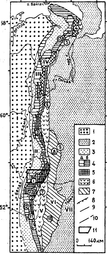
Geological sketch map of the Urals.
1 sedimentary cover of the European plate (Carboniferous to Triassic)
2 Sedimentary cover of the Asian plate (tertiary and later)
3 Permian molasse of the Preuralian foredeep
4 West Uralian paleozoic megazone
5 Central Uralian Proterozoic megazone
6 Tagil-Magnitogorkian megazone
7 East Uralian Megazone
8 Main Uralian Fault
9 boundaries of the mega-zones
in circles are the numbers of the zones:
1 Bashkinan
2 Ural-Tau uplift
3 Kvarkush
4 Kharbey
5 Voykar
6 Tagil
7 Magnitogorsk
8 Rezh
9 East Volcanic
10 East Mogudzhary
11 Sakmara allochtone
12 Zilair
13 Lemva
in roman numbers
I Russian plate
II Preuralian foredeep
III West Uralian
IV Central Uralian
V Tagilo-Magnitogorskian
VI East Uralian
VII Transuralian
[map from Institute of geology in Ufa]
Geology of the Polar Ural
The Polar Ural mainly consists of metamorphic rocks, formed during the
formation of the Ural at the end of the paleozoicum. The Polar Ural can be
divided into three zones. The central zone roughly runs across the watershed,
with the eastern and western zones at both sides.
The eastern zone consists of granite-gneiss dome, the Chobisk gneiss dome. This
area consists of gneiss and granite gneiss with epidote-amphibolite also
occuring in the center. In this zone are a number of alpine localityes, like for
example Svobodnoye, Pogranichnoye, Verkhnee KozhimPonyu, Granitnoye, Nikolai-shor
and Pridorozhnoye. The central zone is the richest in alpine minerals. It
consists mainly of schist and greenstone, but other rocks are also present. In
this zone lay the more famous localities like Puiva, Dodo, Zhellyanoye etc. The
western zone is not a true unit, but consists of a number of ancient volcanoes
of quartz porphyry.
Geology of the Yuzhnye Ural
The western part of the Yuzhnye Ural is made up of the so called Bashkir megannticline. This is an ancient relic from the old European continent. It's main rocks are therefore of Riphean and Vendian age and are mainly sedimentary. Both Riphean and Vendian are subdevisions of the Proterozoicum and they comprise numerous suites. Most of these suite consist of sandstone. They are not very interesting for rockhounds. But there are various mineral deposits within the Bashkir meganticline. Of these Satka is probably the only one with importance for collectors.
East of the Bashkir meganticline is the Uraltau uplift. The Uraltau uplift is the remnant of the old mid oceanic rift. It consists mainly of ophiolites and ophiocalcites together with a number of basic and ultrabasic complexes such as the Khabarny massif and the Katrala massif. Most interesting here is that, as with the modern Mid Atlantic rift, there where black smokers in this rift too. These underwater volcanic vents are known for copper, nickel and iron ores. So some of the Cu, Ni and Fe deposits in the Uraltau uplift are the remnants of such black smokers. Bljava is an example.
references
Paleozoic Intraplate ocean Complexes of the Southern Urals, by E. Kalinina et al, Geophysical Research Abstracts Vol. 6, 2004