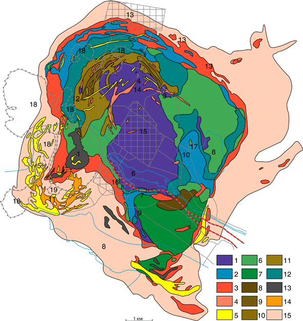
This map is not mine, it is from the Kovdor mining company as is the legend below.
Geological scheme of the Kovdor massif, Murmansk region, Russia. According to Sulimov B.I., Kol'cova T.P., Nechaev S.A., Afanas'eva N.V., Dombrovskaya T.P. (Kovdor Mining Company).
Legend: 1-olivinite, 2-melilite-bearing rocks (turjaite, uncompahgrite), 3-melteigite, ijolite, 4-felspar-bearing ijolite, nepheline sienite, 5-carbonatite; 6-pyroxenite and nepheline-bearing pyroxenite replaced olivinite, 7-jacupirangite, 8-biotitite, 9-11-"Phlogopite complex" (plhlogopite-diopside-forsterite rocks): 9-gigantic-grained (pegmatoid) rocks, 10-coarse-grained rocks, 11-fine-grained rocks, 12-montichellite-amphibole, montichellite-phlogopite, diopside-amphibole rocks replaced melilite-bearing rocks, 13-rocks of the "iron-ore complex" (phoskorite, nelsonite); 14-apatite-francolite ores; 15-fenite. Country rocks: gneisses, amphibolites
Topography: 1-the magnetite quarry (the Iron deposit), 2-the phlogopite quarry (the Phlogopite deposit), 3-the vermiculite quarry, 4-the olivinite quarry, 5-the carbonatite quarry; 6-The Kovdor lake, 7-railway station "Kovdor", 8-receptacle of a draff; 9-m.Yuzhnaya, 10-m.Vysokya, 11-m.Pilkoma-Sel'ga, 12-m.Votcu-Vara, 13-m.Mogo-vid, 14-m.Nizka-vara, 15-t.Kovdor, 16-Kovdor Mining Company, 17-integrated activity of vermiculite; 18-burrow, 19-receptacle "anomalnye ores"